Trail Walking Ranspach - Le Markstein - Le Haag par GR5 et GR532 - Photo

Le Markstein - Le Haag par GR5 et GR532

© OpenStreetMap contributors
Length
Length
13.4 km
Max alt
Max alt
1245 m
Uphill gradient
Uphill gradient
352 m
Km-Effort
Km-Effort  
18.1 km
Min alt
Min alt
1157 m
Downhill gradient
Downhill gradient
352 m
Boucle
Boucle
Yes
Creation date :
2018-10-28 05:54:03.132
Updated on :
2018-10-28 06:00:28.207

(0 Reviews)

Walking
Walking
3h50
Difficulty : Medium

Scan this QR Code to open this trail in the SityTrail application

FREE GPS app for hiking

Logo SityTrail SityTrail

IGN / Geographical institutes

Download SityTrail from the App Store Download SityTrail from Google Play

Logo SityTrail SityTrail Plus

The world is yours!

Download SityTrail from the App Store Download SityTrail from Google Play Download SityTrail on Huawei AppGallery

About

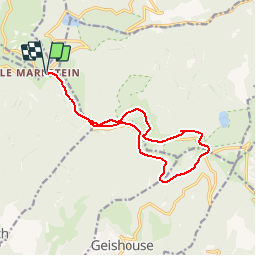
Trail Walking of 13.4 km to be discovered at Grand Est, Haut-Rhin, Ranspach. This trail is proposed by patrickbeyrath.

Description

Le Markstein -Hundsrucken puis GR532 Hundskopf --contourner par chemin non balisé le Hundskopf puis  Moorfeld, reprendre GR532 vers Le Haag puis GR5 vers Abri du Storken et retour par GR5 jusqu'au parking du Markstein

Elevation profile

Positioning

Country:
France
Region :
Grand Est
Department/Province :
Haut-Rhin
Municipality :
Ranspach
Location:
Unknown
Start:(UTM)
353148 ; 5309595 (32T) N.


Close
My subscriptions