Trail Walking Chazelles - La randonnée autour de Chazelles  - Photo

La randonnée autour de Chazelles

© OpenStreetMap contributors
Length
Length
9.6 km
Max alt
Max alt
131 m
Uphill gradient
Uphill gradient
112 m
Km-Effort
Km-Effort  
11.1 km
Min alt
Min alt
88 m
Downhill gradient
Downhill gradient
112 m
Boucle
Boucle
Yes
Creation date :
2018-11-04 13:54:34.395
Updated on :
2018-11-04 16:28:27.489

(0 Reviews)

Walking
Walking
2h32
Difficulty : Easy

Scan this QR Code to open this trail in the SityTrail application

FREE GPS app for hiking

Logo SityTrail SityTrail

IGN / Geographical institutes

Download SityTrail from the App Store Download SityTrail from Google Play

Logo SityTrail SityTrail World

The world is yours!

Download SityTrail from the App Store Download SityTrail from Google Play Download SityTrail on Huawei AppGallery

About

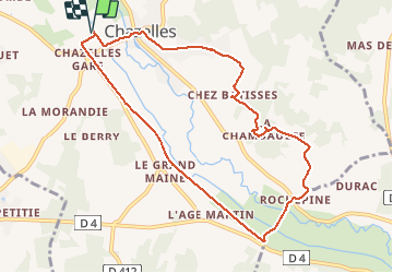
Trail Walking of 9.6 km to be discovered at New Aquitaine, Charente, Chazelles. This trail is proposed by alainjoseph6.

Description

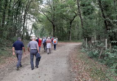
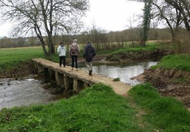
Nous démarrons la randonnée après les terrains de football par la voie verte  jusqu'à Rochepine. Le village de chez Bâtisse est sympa. Puis Chazelles.

Elevation profile

Photos

Positioning

Country:
France
Region :
New Aquitaine
Department/Province :
Charente
Municipality :
Chazelles
Location:
Unknown
Start:(UTM)
294264 ; 5058255 (31T) N.

Trails nearby

Trail Walking Pranzac - Pranzac et ses petits villages. - Photo
Walking
alainjoseph6

Walking

Medium
Pranzac, New Aquitaine, Charente, France
7.8 km | 9 km-effort
2h 26min
Yes
Trail Walking Chazelles - Les Grottes du Quéroy -gros terme et Combe - Photo
Walking
alainjoseph6

Walking

Medium
(1)
Chazelles, New Aquitaine, Charente, France
8.2 km | 9.6 km-effort
2h 24min
Yes
Trail Walking Bunzac - BUNZAC 16110 ..départ de Puy cocu > combebrune > les Denis > le château des deffends - Photo
Walking
alainjoseph6

Walking

Easy
Bunzac, New Aquitaine, Charente, France
9.3 km | 10.8 km-effort
3h 9min
Yes
Trail Walking Moulins-sur-Tardoire - La rando de Vilhoneur côté Nord - Photo
Walking
alainjoseph6

Walking

Easy
Moulins-sur-Tardoire, New Aquitaine, Charente, France
7.1 km | 8.1 km-effort
2h 12min
Yes
Trail Mountain bike Chazelles - Chazelles - Brégout - Photo
Mountain bike
tracegps

Mountain bike

Difficult
(1)
Chazelles, New Aquitaine, Charente, France
46 km | 57 km-effort
4h 0min
No
Trail Walking Bunzac - Départ de puy cocu et les petits villages autour de Pranzac 16 110 - Photo
Walking
alainjoseph6

Walking

Medium
Bunzac, New Aquitaine, Charente, France
8.9 km | 10.2 km-effort
2h 18min
Yes
Trail Walking Moulins-sur-Tardoire - Vilhonneur0504 - Photo
Walking
dededavid

Walking

Medium
Moulins-sur-Tardoire, New Aquitaine, Charente, France
6 km | 6.8 km-effort
2h 31min
Yes
Trail Walking Chazelles - Les grottes du Queroy en passant par le pont Romain de Gros Terme - Photo
Walking
alainjoseph6

Walking

Easy
Chazelles, New Aquitaine, Charente, France
9.8 km | 11.2 km-effort
2h 47min
Yes
Trail Walking Saint-Germain-de-Montbron - Entre Saint Germain  et Mirandes  - Photo
Walking
alainjoseph6

Walking

Very easy
Saint-Germain-de-Montbron, New Aquitaine, Charente, France
9.7 km | 11.1 km-effort
2h 21min
Yes


Close
My subscriptions