


Autour de Rammersmatt

patrickbeyrath
User


3h14
Difficulty : Difficult

FREE GPS app for hiking
 SityTrail
IGN / Geographical institutes
SityTrail Plus
The world is yours!
About
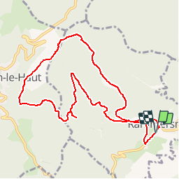
Trail Walking of 10.1 km to be discovered at Grand Est, Haut-Rhin, Rammersmatt. This trail is proposed by patrickbeyrath.
Description
Départ de la mairie de Rammersmatt - triangle jaune vers Spannplatz puis rect. rouge blanc rouge vers Bourbach le Haut puis rond circulaire vers le Hundsruck et prendre triangle jaune vers Abri du Hochburg et retour
Positioning
Comments