


BURNHAUPT_18

bubu90
User
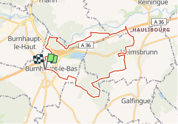

Length
17.8 km

Max alt
317 m

Uphill gradient
170 m
Km-Effort
20 km

Min alt
262 m

Downhill gradient
170 m
Boucle
Yes
Creation date :
2018-11-25 10:04:49.865
Updated on :
2018-11-25 10:11:22.728
4h24
Difficulty : Easy

FREE GPS app for hiking
 SityTrail
IGN / Geographical institutes
SityTrail Plus
The world is yours!
About
Trail Walking of 17.8 km to be discovered at Grand Est, Haut-Rhin, Burnhaupt-le-Bas. This trail is proposed by bubu90.
Positioning
Country:
France
Region :
Grand Est
Department/Province :
Haut-Rhin
Municipality :
Burnhaupt-le-Bas
Location:
Unknown
Start:(Dec)
Start:(UTM)
362079 ; 5286710 (32T) N.
Comments