


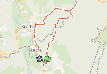
Oderen - autour du Gommkopf - Chemin de Laffe- Strasshisel

patrickbeyrath
User


3h05
Difficulty : Difficult

FREE GPS app for hiking
 SityTrail
IGN / Geographical institutes
SityTrail Plus
The world is yours!
About
Trail Walking of 9.2 km to be discovered at Grand Est, Haut-Rhin, Oderen. This trail is proposed by patrickbeyrath.
Description
Parking arboriculteurs, rue de Vontay - triangle bleu Uhufels - Pfaffenkopf - triangle jaune Gommkopf - Chemin de Laffe puis rectangle rouge blanc rouge Holtzplatz aller direction Laffe et prendre à gauche indication Strasshisel et aller juste à l'abri et prendre le retour le long de Kruth- Oderen-
Positioning
Comments