Trail Snowshoes Corrençon-en-Vercors - 20181205044535-12180-data - Photo
 harydh
harydh

User GUIDE

© OpenStreetMap contributors
Length
Length
4.2 km
Max alt
Max alt
2012 m
Uphill gradient
Uphill gradient
815 m
Km-Effort
Km-Effort  
12.5 km
Min alt
Min alt
1234 m
Downhill gradient
Downhill gradient
44 m
Boucle
Boucle
No
Creation date :
2018-12-05 13:46:23.411
Updated on :
2018-12-05 13:50:44.412

(0 Reviews)

Snowshoes
Snowshoes
--
Difficulty : Unknown

Scan this QR Code to open this trail in the SityTrail application

FREE GPS app for hiking

Logo SityTrail SityTrail

IGN / Geographical institutes

Download SityTrail from the App Store Download SityTrail from Google Play

Logo SityTrail SityTrail Plus

The world is yours!

Download SityTrail from the App Store Download SityTrail from Google Play Download SityTrail on Huawei AppGallery

About

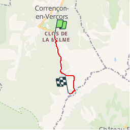
Trail Snowshoes of 4.2 km to be discovered at Auvergne-Rhône-Alpes, Isère, Corrençon-en-Vercors. This trail is proposed by harydh.

Description

Départ de la randonnée, au lieu-dit "Clos de la Balme" de Correncon.
A Corrençon-en-Vercors, continuer jusqu’au bout de la D 215, passer le parking du gîte d’étape du golf, et monter se garer au Clos de la Balme. Panneaux indicateurs.

Elevation profile

Positioning

Country:
France
Region :
Auvergne-Rhône-Alpes
Department/Province :
Isère
Municipality :
Corrençon-en-Vercors
Location:
Unknown
Start:(UTM)
699252 ; 4988345 (31T) N.


Close
My subscriptions