


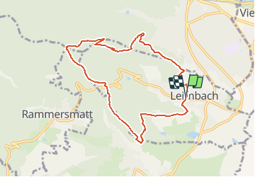
Leimbach - Chalet Zuber

patrickbeyrath
User

Length
8.5 km

Max alt
647 m

Uphill gradient
341 m
Km-Effort
13 km

Min alt
357 m

Downhill gradient
337 m
Boucle
Yes
Creation date :
2018-12-07 08:21:02.977
Updated on :
2018-12-07 08:27:56.896
2h42
Difficulty : Medium

FREE GPS app for hiking
 SityTrail
IGN / Geographical institutes
SityTrail Plus
The world is yours!
About
Trail Walking of 8.5 km to be discovered at Grand Est, Haut-Rhin, Leimbach. This trail is proposed by patrickbeyrath.
Description
Parking mairie Leimbach - Les Trois Chênes ) Tempel - Muhlberg - Col du Teufelsgrund - Chalet Zuber - descente rond rouge puis prendre à gauche Riegelsbourg et retour parking
Positioning
Country:
France
Region :
Grand Est
Department/Province :
Haut-Rhin
Municipality :
Leimbach
Location:
Unknown
Start:(Dec)
Start:(UTM)
357786 ; 5295059 (32T) N.
Comments