


la sinne / puits d'Auzon

amiral13
User GUIDE

Length
18.1 km

Max alt
657 m

Uphill gradient
313 m
Km-Effort
22 km

Min alt
529 m

Downhill gradient
315 m
Boucle
Yes
Creation date :
2018-12-30 12:36:16.802
Updated on :
2018-12-30 23:04:02.11
2h52
Difficulty : Easy

FREE GPS app for hiking
 SityTrail
IGN / Geographical institutes
SityTrail Plus
The world is yours!
About
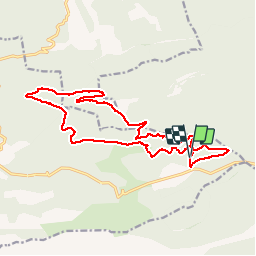
Trail Mountain bike of 18.1 km to be discovered at Provence-Alpes-Côte d'Azur, Bouches-du-Rhône, Vauvenargues. This trail is proposed by amiral13.
Description
Rando vtt facile correspondant au tracé bleu, en évitant le petit tronçon technique entre les côtes 614 et 556.
Positioning
Country:
France
Region :
Provence-Alpes-Côte d'Azur
Department/Province :
Bouches-du-Rhône
Municipality :
Vauvenargues
Location:
Unknown
Start:(Dec)
Start:(UTM)
717115 ; 4826263 (31T) N.
Comments