


St Amarin - Meerbaechlé par la vue des Alpes

patrickbeyrath
User
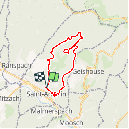

Length
11.7 km

Max alt
859 m

Uphill gradient
570 m
Km-Effort
19.3 km

Min alt
420 m

Downhill gradient
569 m
Boucle
Yes
Creation date :
2019-01-01 12:39:17.564
Updated on :
2019-01-04 10:18:54.694
--
Difficulty : Medium

FREE GPS app for hiking
 SityTrail
IGN / Geographical institutes
SityTrail Plus
The world is yours!
About
Trail On foot of 11.7 km to be discovered at Grand Est, Haut-Rhin, Saint-Amarin. This trail is proposed by patrickbeyrath.
Positioning
Country:
France
Region :
Grand Est
Department/Province :
Haut-Rhin
Municipality :
Saint-Amarin
Location:
Unknown
Start:(Dec)
Start:(UTM)
352869 ; 5304367 (32T) N.
Comments