


Circuit LB St Hippolyte Thannenkirch

Tourisme Equestre Alsace
Promouvoir le Tourisme Equestre en Alsace GUIDE+
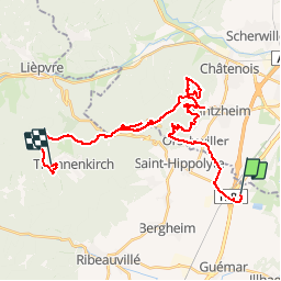

Length
30 km

Max alt
749 m

Uphill gradient
1101 m
Km-Effort
44 km

Min alt
169 m

Downhill gradient
646 m
Boucle
No
Creation date :
2019-01-06 19:38:56.761
Updated on :
2019-01-07 10:29:23.174
41m
Difficulty : Easy

FREE GPS app for hiking
 SityTrail
IGN / Geographical institutes
SityTrail Plus
The world is yours!
About
Trail Horseback riding of 30 km to be discovered at Grand Est, Haut-Rhin, Saint-Hippolyte. This trail is proposed by Tourisme Equestre Alsace.
Photos


Positioning
Country:
France
Region :
Grand Est
Department/Province :
Haut-Rhin
Municipality :
Saint-Hippolyte
Location:
Unknown
Start:(Dec)
Start:(UTM)
381771 ; 5342006 (32U) N.
Comments