


Sciecq (vallée de Périgny)

olaze
User

Length
8.5 km

Max alt
65 m

Uphill gradient
90 m
Km-Effort
9.7 km

Min alt
21 m

Downhill gradient
92 m
Boucle
Yes
Creation date :
2019-01-08 17:50:31.922
Updated on :
2019-01-08 18:12:30.401
2h08
Difficulty : Medium

FREE GPS app for hiking
 SityTrail
IGN / Geographical institutes
SityTrail Plus
The world is yours!
About
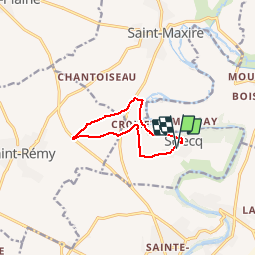
Trail Walking of 8.5 km to be discovered at New Aquitaine, Deux-Sèvres, Sciecq. This trail is proposed by olaze.
Description
Départ du parking de la salle des fêtes de Sciecq.
Descente bords de Sèvre , passage moulin de Sciecq ,vallée de Périgny, six chemins , Croisette et retour
Photos
 - Photo 1")
 - Photo 2")
Positioning
Country:
France
Region :
New Aquitaine
Department/Province :
Deux-Sèvres
Municipality :
Sciecq
Location:
Unknown
Start:(Dec)
Start:(UTM)
694376 ; 5138496 (30T) N.
Comments