


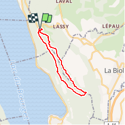
CORSUET: CHAMBOTTE - HAUT GRANGES BRISON - MEYRIEUX - RETOUR CRETES

djeepee74
User

Length
10.2 km

Max alt
847 m

Uphill gradient
458 m
Km-Effort
16.3 km

Min alt
532 m

Downhill gradient
451 m
Boucle
Yes
Creation date :
2019-01-15 20:38:40.156
Updated on :
2019-04-10 16:24:23.094
3h00
Difficulty : Medium

FREE GPS app for hiking
 SityTrail
IGN / Geographical institutes
SityTrail Plus
The world is yours!
About
Trail Walking of 10.2 km to be discovered at Auvergne-Rhône-Alpes, Savoy, Entrelacs. This trail is proposed by djeepee74.
Description
BOUCLE
C'est raide sous la croix du Meyrieux !
Positioning
Country:
France
Region :
Auvergne-Rhône-Alpes
Department/Province :
Savoy
Municipality :
Entrelacs
Location:
Saint-Germain-la-Chambotte
Start:(Dec)
Start:(UTM)
723385 ; 5073290 (31T) N.
Comments