


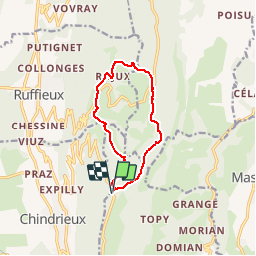
SAPENAY / CLERGEON: SAPENAY - LE TOUR DE MONTCLERGEON

djeepee74
User

Length
10.3 km

Max alt
986 m

Uphill gradient
323 m
Km-Effort
14.6 km

Min alt
806 m

Downhill gradient
321 m
Boucle
Yes
Creation date :
2019-01-18 18:20:03.395
Updated on :
2019-06-15 12:05:43.689
3h00
Difficulty : Medium

FREE GPS app for hiking
 SityTrail
IGN / Geographical institutes
SityTrail Plus
The world is yours!
About
Trail Walking of 10.3 km to be discovered at Auvergne-Rhône-Alpes, Savoy, Entrelacs. This trail is proposed by djeepee74.
Description
BOUCLE
Photos


Positioning
Country:
France
Region :
Auvergne-Rhône-Alpes
Department/Province :
Savoy
Municipality :
Entrelacs
Location:
Cessens
Start:(Dec)
Start:(UTM)
722824 ; 5078662 (31T) N.
Comments