Trail Walking Laprade - Laprade - Photo
 dorcier
dorcier

User

© OpenStreetMap contributors
Length
Length
11.3 km
Max alt
Max alt
128 m
Uphill gradient
Uphill gradient
134 m
Km-Effort
Km-Effort  
13.1 km
Min alt
Min alt
41 m
Downhill gradient
Downhill gradient
135 m
Boucle
Boucle
Yes
Creation date :
2019-02-03 14:07:12.0
Updated on :
2019-02-07 18:02:11.419

(0 Reviews)

Walking
Walking
2h51
Difficulty : Easy

Scan this QR Code to open this trail in the SityTrail application

FREE GPS app for hiking

Logo SityTrail SityTrail

IGN / Geographical institutes

Download SityTrail from the App Store Download SityTrail from Google Play

Logo SityTrail SityTrail World

The world is yours!

Download SityTrail from the App Store Download SityTrail from Google Play Download SityTrail on Huawei AppGallery

About

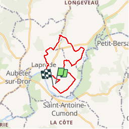
Trail Walking of 11.3 km to be discovered at New Aquitaine, Charente, Laprade. This trail is proposed by dorcier.

Description

Départ depuis la statue de l'Homme Libre, conçue à partir des poutres de l'ancien pont Eiffel de la voie ferrée Périgueux-Ribérac.
Du village de Laprade vous vous dirigerez vers le moulin de Poltrot (Halte pique-nique, buvette, jeux). Magnifiques panorama sur Aubeterre classé parmi les plus beaux villages de France. Vallée de la Dronne.

Elevation profile

Photos

Points of interest

Point of interest Laprade - Statue del'Homme Libre - Photo
dorcier

Positioning

Country:
France
Region :
New Aquitaine
Department/Province :
Charente
Municipality :
Laprade
Location:
Unknown
Start:(UTM)
279761 ; 5016589 (31T) N.

Trails nearby

Trail Walking Saint-Romain - saint-romain 16 03 sept 2019 - Photo
Walking
bert16

Walking

Medium
Saint-Romain, New Aquitaine, Charente, France
7.8 km | 9.5 km-effort
1h 57min
Yes
Trail Walking Aubeterre-sur-Dronne - Aubeterre-Poltrot 28 juin 2018 - Photo
Walking
bert16

Walking

Easy
(1)
Aubeterre-sur-Dronne, New Aquitaine, Charente, France
11.2 km | 13.9 km-effort
3h 0min
Yes
Trail Walking Aubeterre-sur-Dronne - dom - Photo
Walking
bert16

Walking

Easy
Aubeterre-sur-Dronne, New Aquitaine, Charente, France
27 km | 33 km-effort
3h 14min
No
Trail Walking Saint-Romain - Saint-Romain - Photo
Walking
dorcier

Walking

Medium
Saint-Romain, New Aquitaine, Charente, France
11.3 km | 13.6 km-effort
2h 35min
Yes
Trail Walking Laprade - Aubeterre  - Photo
Walking
dorcier

Walking

Very easy
Laprade, New Aquitaine, Charente, France
5.2 km | 5.6 km-effort
1h 15min
Yes
Trail Mountain bike Nabinaud - Circuit VTT n^5 - Photo
Mountain bike
Oupia82

Mountain bike

Medium
Nabinaud, New Aquitaine, Charente, France
25 km | 30 km-effort
1h 33min
Yes
Trail Walking Bonnes - Bonnes 16 - Photo
Walking
bert16

Walking

Easy
Bonnes, New Aquitaine, Charente, France
8.2 km | 10 km-effort
2h 10min
Yes
Trail Walking Bonnes - Bonnes 16390 - Photo
Walking
bert16

Walking

Easy
Bonnes, New Aquitaine, Charente, France
8.3 km | 10 km-effort
2h 11min
Yes
Trail Walking Aubeterre-sur-Dronne - Aubeterre - Photo
Walking
phil24

Walking

Medium
Aubeterre-sur-Dronne, New Aquitaine, Charente, France
11.3 km | 13.9 km-effort
2h 58min
Yes


Close
My subscriptions