


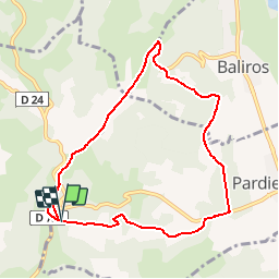
SityTrail - pardies pietat et ses fontaines M1

LouisROGER
User GUIDE

Length
9 km

Max alt
402 m

Uphill gradient
227 m
Km-Effort
12 km

Min alt
231 m

Downhill gradient
230 m
Boucle
Yes
Creation date :
2019-02-05 11:42:42.548
Updated on :
2019-02-05 11:46:34.362
2h33
Difficulty : Medium

FREE GPS app for hiking
 SityTrail
IGN / Geographical institutes
SityTrail Plus
The world is yours!
About
Trail Walking of 9 km to be discovered at New Aquitaine, Pyrénées-Atlantiques, Pardies-Piétat. This trail is proposed by LouisROGER.
Description
coordonees de départ notre dame de pietat
N 43 12 34.9
W 000 20 08.2
Positioning
Country:
France
Region :
New Aquitaine
Department/Province :
Pyrénées-Atlantiques
Municipality :
Pardies-Piétat
Location:
Unknown
Start:(Dec)
Start:(UTM)
716446 ; 4787570 (30T) N.
Comments