


ht Ribeaupierre

Raeis
User
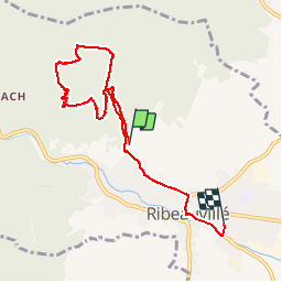

Length
6.7 km

Max alt
633 m

Uphill gradient
337 m
Km-Effort
11.4 km

Min alt
228 m

Downhill gradient
398 m
Boucle
No
Creation date :
2019-02-09 15:26:05.632
Updated on :
2019-02-09 16:41:56.22
1h15
Difficulty : Medium

FREE GPS app for hiking
 SityTrail
IGN / Geographical institutes
SityTrail Plus
The world is yours!
About
Trail Nordic walking of 6.7 km to be discovered at Grand Est, Haut-Rhin, Ribeauvillé. This trail is proposed by Raeis.
Positioning
Country:
France
Region :
Grand Est
Department/Province :
Haut-Rhin
Municipality :
Ribeauvillé
Location:
Unknown
Start:(Dec)
Start:(UTM)
374851 ; 5339862 (32U) N.
Comments