


jurançonRs

LouisROGER
User GUIDE
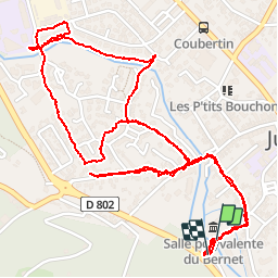

Length
4.2 km

Max alt
180 m

Uphill gradient
20 m
Km-Effort
4.5 km

Min alt
168 m

Downhill gradient
21 m
Boucle
Yes
Creation date :
2019-02-12 14:11:17.86
Updated on :
2019-02-12 16:45:46.825
2h33
Difficulty : Very easy

FREE GPS app for hiking
 SityTrail
IGN / Geographical institutes
SityTrail Plus
The world is yours!
About
Trail Walking of 4.2 km to be discovered at New Aquitaine, Pyrénées-Atlantiques, Jurançon. This trail is proposed by LouisROGER.
Photos


Positioning
Country:
France
Region :
New Aquitaine
Department/Province :
Pyrénées-Atlantiques
Municipality :
Jurançon
Location:
Unknown
Start:(Dec)
Start:(UTM)
711478 ; 4795682 (30T) N.
Comments