Trail On foot Les Autels-Villevillon - Les Autels Villevillon 25.68 - Photo
 togolo28
togolo28

User

© OpenStreetMap contributors
Length
Length
26 km
Max alt
Max alt
197 m
Uphill gradient
Uphill gradient
126 m
Km-Effort
Km-Effort  
27 km
Min alt
Min alt
164 m
Downhill gradient
Downhill gradient
126 m
Boucle
Boucle
Yes
Creation date :
2019-02-14 15:13:31.718
Updated on :
2019-02-15 11:51:48.784

(0 Reviews)

On foot
On foot
--
Difficulty : Medium

Scan this QR Code to open this trail in the SityTrail application

FREE GPS app for hiking

Logo SityTrail SityTrail

IGN / Geographical institutes

Download SityTrail from the App Store Download SityTrail from Google Play

Logo SityTrail SityTrail World

The world is yours!

Download SityTrail from the App Store Download SityTrail from Google Play Download SityTrail on Huawei AppGallery

About

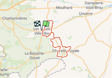
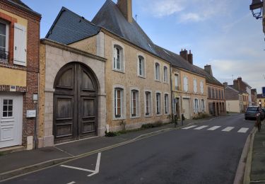
Trail On foot of 26 km to be discovered at Centre-Loire Valley, Eure-et-Loir, Les Autels-Villevillon. This trail is proposed by togolo28.

Description

Attention, 16,7 Km de route! Peu de chemins dans les environs!

Elevation profile

Positioning

Country:
France
Region :
Centre-Loire Valley
Department/Province :
Eure-et-Loir
Municipality :
Les Autels-Villevillon
Location:
Unknown
Start:(UTM)
351029 ; 5337570 (31U) N.

Trails nearby

Trail Running La Bazoche-Gouet - La Bazoches-Gouet - Photo
Running
huguesb

Running

Very easy
La Bazoche-Gouet, Centre-Loire Valley, Eure-et-Loir, France
3.6 km | 4.1 km-effort
47min
Yes
Trail Walking Les Autels-Villevillon - Villevillon Perche Gouet 9.4 Km - Photo
Walking
ODDAD78

Walking

Easy
Les Autels-Villevillon, Centre-Loire Valley, Eure-et-Loir, France
9.4 km | 9.9 km-effort
2h 17min
Yes
Trail Walking Chapelle-Royale - Chapelle Royale 21.36-16732892 - Photo
Walking
togolo28

Walking

Medium
Chapelle-Royale, Centre-Loire Valley, Eure-et-Loir, France
21 km | 23 km-effort
5h 11min
Yes
Trail Walking Charbonnières - 13631126-Charbonnières 17.18 - Photo
Walking
togolo28

Walking

Medium
Charbonnières, Centre-Loire Valley, Eure-et-Loir, France
17.2 km | 19.7 km-effort
Unknown
Yes
Trail Walking La Bazoche-Gouet - La Bazoche Gouet 17.10 - Photo
Walking
togolo28

Walking

Medium
La Bazoche-Gouet, Centre-Loire Valley, Eure-et-Loir, France
17.1 km | 18.4 km-effort
Unknown
Yes
Trail Walking La Bazoche-Gouet - OR-5489839--Bazoche-Gouet (La):La Bazoche Gouet 25.71 - Photo
Walking
togolo28

Walking

Medium
La Bazoche-Gouet, Centre-Loire Valley, Eure-et-Loir, France
26 km | 28 km-effort
Unknown
Yes
Trail Walking La Bazoche-Gouet - La Bazoche Gouët Vallée de l'Yerre 11.9 Km - Photo
Walking
ODDAD78

Walking

Very easy
La Bazoche-Gouet, Centre-Loire Valley, Eure-et-Loir, France
11.9 km | 12.6 km-effort
2h 49min
Yes
Trail Walking Chapelle-Royale - Chapelle Royale 13.76 - Photo
Walking
togolo28

Walking

Easy
Chapelle-Royale, Centre-Loire Valley, Eure-et-Loir, France
13.8 km | 14.7 km-effort
3h 16min
Yes
Trail Walking La Bazoche-Gouet - La Bazoche Gouet 25 - Photo
Walking
togolo28

Walking

Medium
La Bazoche-Gouet, Centre-Loire Valley, Eure-et-Loir, France
26 km | 28 km-effort
6h 7min
Yes


Close
My subscriptions