


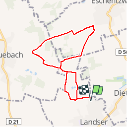
Landser Bruebach Eschentzwiller

domi68440
User

Length
7.6 km

Max alt
341 m

Uphill gradient
148 m
Km-Effort
9.6 km

Min alt
268 m

Downhill gradient
148 m
Boucle
Yes
Creation date :
2019-02-16 08:52:39.093
Updated on :
2019-02-16 19:41:21.576
1h49
Difficulty : Easy

FREE GPS app for hiking
 SityTrail
IGN / Geographical institutes
SityTrail Plus
The world is yours!
About
Trail Walking of 7.6 km to be discovered at Grand Est, Haut-Rhin, Landser. This trail is proposed by domi68440.
Positioning
Country:
France
Region :
Grand Est
Department/Province :
Haut-Rhin
Municipality :
Landser
Location:
Unknown
Start:(Dec)
Start:(UTM)
379179 ; 5283089 (32T) N.
Comments