


Col de Herrenfluh - Molkenrain - Chapelle du Freundstein - Abri Becherkopf et retour

patrickbeyrath
User
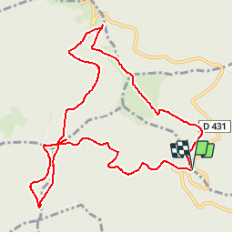

Length
11.1 km

Max alt
1088 m

Uphill gradient
409 m
Km-Effort
16.6 km

Min alt
812 m

Downhill gradient
416 m
Boucle
Yes
Creation date :
2019-02-22 08:28:28.402
Updated on :
2019-02-22 08:52:29.685
--
Difficulty : Medium

FREE GPS app for hiking
 SityTrail
IGN / Geographical institutes
SityTrail Plus
The world is yours!
About
Trail On foot of 11.1 km to be discovered at Grand Est, Haut-Rhin, Uffholtz. This trail is proposed by patrickbeyrath.
Positioning
Country:
France
Region :
Grand Est
Department/Province :
Haut-Rhin
Municipality :
Uffholtz
Location:
Unknown
Start:(Dec)
Start:(UTM)
361067 ; 5300802 (32T) N.
Comments
Belle rando, avec une belle montée au début et une suite tranquille à partir de la FA du Molkenrain.