


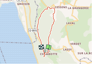
SAPENAY: LA CHAMBOTTE - CHAPELLE DE CESSENS (Boucle... aller: via sous les falaises)

djeepee74
User

Length
6.3 km

Max alt
824 m

Uphill gradient
298 m
Km-Effort
10.3 km

Min alt
595 m

Downhill gradient
292 m
Boucle
Yes
Creation date :
2019-02-27 16:49:12.546
Updated on :
2020-01-07 19:51:16.894
2h00
Difficulty : Easy

FREE GPS app for hiking
 SityTrail
IGN / Geographical institutes
SityTrail Plus
The world is yours!
About
Trail Walking of 6.3 km to be discovered at Auvergne-Rhône-Alpes, Savoy, Entrelacs. This trail is proposed by djeepee74.
Description
BOUCLE
Circuit à parcourir dans le sens des aiguilles d'une montre recommandé: En effet, la montée "sous les falaises" est raide et la trace souvent en dévers... A éviter par terrain humide !
Positioning
Country:
France
Region :
Auvergne-Rhône-Alpes
Department/Province :
Savoy
Municipality :
Entrelacs
Location:
Saint-Germain-la-Chambotte
Start:(Dec)
Start:(UTM)
723345 ; 5073284 (31T) N.
Comments