


lees atyas

lefrancm
User
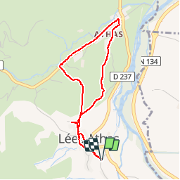

Length
4 km

Max alt
499 m

Uphill gradient
99 m
Km-Effort
5.3 km

Min alt
433 m

Downhill gradient
100 m
Boucle
Yes
Creation date :
2014-12-10 00:00:00.0
Updated on :
2014-12-10 00:00:00.0
1h00
Difficulty : Very easy

FREE GPS app for hiking
 SityTrail
IGN / Geographical institutes
SityTrail Plus
The world is yours!
About
Trail Walking of 4 km to be discovered at New Aquitaine, Pyrénées-Atlantiques, Lées-Athas. This trail is proposed by lefrancm.
Positioning
Country:
France
Region :
New Aquitaine
Department/Province :
Pyrénées-Atlantiques
Municipality :
Lées-Athas
Location:
Unknown
Start:(Dec)
Start:(UTM)
694071 ; 4760588 (30T) N.
Comments