


st jean d arves. les chambons

laurentnecca
User
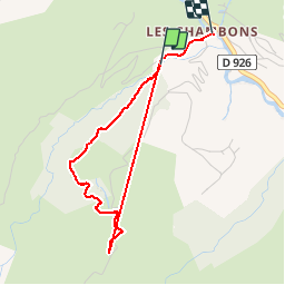

Length
3.4 km

Max alt
1704 m

Uphill gradient
268 m
Km-Effort
7.1 km

Min alt
1401 m

Downhill gradient
291 m
Boucle
No
Creation date :
2019-03-20 12:31:09.12
Updated on :
2019-03-21 15:41:11.474
1h18
Difficulty : Very easy

FREE GPS app for hiking
 SityTrail
IGN / Geographical institutes
SityTrail Plus
The world is yours!
About
Trail Walking of 3.4 km to be discovered at Auvergne-Rhône-Alpes, Savoy, Saint-Jean-d'Arves. This trail is proposed by laurentnecca.
Positioning
Country:
France
Region :
Auvergne-Rhône-Alpes
Department/Province :
Savoy
Municipality :
Saint-Jean-d'Arves
Location:
Unknown
Start:(Dec)
Start:(UTM)
284808 ; 5009260 (32T) N.
Comments