


2tablesBinWeg

pythonmichel
User
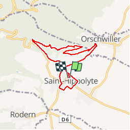

Length
7.3 km

Max alt
411 m

Uphill gradient
202 m
Km-Effort
10 km

Min alt
231 m

Downhill gradient
202 m
Boucle
Yes
Creation date :
2019-03-23 14:45:38.859
Updated on :
2019-03-23 16:54:09.295
1h51
Difficulty : Easy

FREE GPS app for hiking
 SityTrail
IGN / Geographical institutes
SityTrail Plus
The world is yours!
About
Trail Walking of 7.3 km to be discovered at Grand Est, Haut-Rhin, Saint-Hippolyte. This trail is proposed by pythonmichel.
Positioning
Country:
France
Region :
Grand Est
Department/Province :
Haut-Rhin
Municipality :
Saint-Hippolyte
Location:
Unknown
Start:(Dec)
Start:(UTM)
378916 ; 5343516 (32U) N.
Comments