


geo

pythonmichel
User
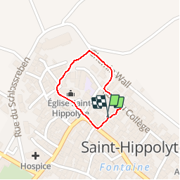

Length
505 m

Max alt
257 m

Uphill gradient
9 m
Km-Effort
625 m

Min alt
245 m

Downhill gradient
9 m
Boucle
Yes
Creation date :
2019-03-29 09:42:41.421
Updated on :
2019-03-29 09:49:48.891
6m
Difficulty : Very easy

FREE GPS app for hiking
 SityTrail
IGN / Geographical institutes
SityTrail Plus
The world is yours!
About
Trail Walking of 505 m to be discovered at Grand Est, Haut-Rhin, Saint-Hippolyte. This trail is proposed by pythonmichel.
Photos


Positioning
Country:
France
Region :
Grand Est
Department/Province :
Haut-Rhin
Municipality :
Saint-Hippolyte
Location:
Unknown
Start:(Dec)
Start:(UTM)
378887 ; 5343519 (32U) N.
Comments