


moi

pythonmichel
User
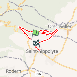

Length
5.4 km

Max alt
409 m

Uphill gradient
135 m
Km-Effort
7.4 km

Min alt
245 m

Downhill gradient
177 m
Boucle
No
Creation date :
2019-03-30 08:26:56.52
Updated on :
2019-03-30 19:12:45.721
1h59
Difficulty : Very easy

FREE GPS app for hiking
 SityTrail
IGN / Geographical institutes
SityTrail Plus
The world is yours!
About
Trail Walking of 5.4 km to be discovered at Grand Est, Haut-Rhin, Saint-Hippolyte. This trail is proposed by pythonmichel.
Positioning
Country:
France
Region :
Grand Est
Department/Province :
Haut-Rhin
Municipality :
Saint-Hippolyte
Location:
Unknown
Start:(Dec)
Start:(UTM)
378522 ; 5343954 (32U) N.
Comments