


Lagauliere

dlaudain
User
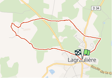

Length
4.8 km

Max alt
449 m

Uphill gradient
72 m
Km-Effort
5.8 km

Min alt
398 m

Downhill gradient
71 m
Boucle
Yes
Creation date :
2019-03-31 13:01:53.488
Updated on :
2019-04-14 13:05:51.51
1h10
Difficulty : Very easy

FREE GPS app for hiking
 SityTrail
IGN / Geographical institutes
SityTrail Plus
The world is yours!
About
Trail Walking of 4.8 km to be discovered at New Aquitaine, Corrèze, Lagraulière. This trail is proposed by dlaudain.
Description
Agréable mais malheureusement la moitié sur la route
Photos


Positioning
Country:
France
Region :
New Aquitaine
Department/Province :
Corrèze
Municipality :
Lagraulière
Location:
Unknown
Start:(Dec)
Start:(UTM)
393366 ; 5023053 (31T) N.
Comments