


marais albens

gerando
User
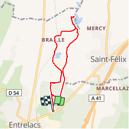

Length
7.1 km

Max alt
370 m

Uphill gradient
49 m
Km-Effort
7.7 km

Min alt
347 m

Downhill gradient
49 m
Boucle
Yes
Creation date :
2019-04-10 11:46:06.298
Updated on :
2019-04-10 13:53:15.317
2h06
Difficulty : Very easy

FREE GPS app for hiking
 SityTrail
IGN / Geographical institutes
SityTrail Plus
The world is yours!
About
Trail Walking of 7.1 km to be discovered at Auvergne-Rhône-Alpes, Savoy, Entrelacs. This trail is proposed by gerando.
Positioning
Country:
France
Region :
Auvergne-Rhône-Alpes
Department/Province :
Savoy
Municipality :
Entrelacs
Location:
Unknown
Start:(Dec)
Start:(UTM)
729599 ; 5074756 (31T) N.
Comments