


Orgnac

houbart
User
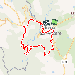

Length
8.4 km

Max alt
369 m

Uphill gradient
309 m
Km-Effort
12.5 km

Min alt
195 m

Downhill gradient
309 m
Boucle
Yes
Creation date :
2019-04-12 16:11:24.1
Updated on :
2025-02-08 09:14:26.104
2h50
Difficulty : Difficult

FREE GPS app for hiking
 SityTrail
IGN / Geographical institutes
SityTrail Plus
The world is yours!
About
Trail Walking of 8.4 km to be discovered at New Aquitaine, Corrèze, Orgnac-sur-Vézère. This trail is proposed by houbart.
Description
Au point de départ, on peut admirer les vitraux de Kim En Joong, de l'église Saint-Martial. Balade dans les bois puis le long de la Loyre, hauts lieux de la Résistance (stèle).
Positioning
Country:
France
Region :
New Aquitaine
Department/Province :
Corrèze
Municipality :
Orgnac-sur-Vézère
Location:
Unknown
Start:(Dec)
Start:(UTM)
377860 ; 5020989 (31T) N.
Comments