


Rougnac 13-04-2019

jmrobin
User
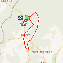

Length
6.2 km

Max alt
203 m

Uphill gradient
98 m
Km-Effort
7.5 km

Min alt
126 m

Downhill gradient
96 m
Boucle
Yes
Creation date :
2019-04-13 13:27:01.158
Updated on :
2019-04-13 15:28:20.734
1h59
Difficulty : Very easy

FREE GPS app for hiking
 SityTrail
IGN / Geographical institutes
SityTrail Plus
The world is yours!
About
Trail Walking of 6.2 km to be discovered at New Aquitaine, Charente, Combiers. This trail is proposed by jmrobin.
Positioning
Country:
France
Region :
New Aquitaine
Department/Province :
Charente
Municipality :
Combiers
Location:
Unknown
Start:(Dec)
Start:(UTM)
296410 ; 5043722 (31T) N.
Comments