


Boyard_ville

olaze
User
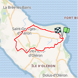

Length
26 km

Max alt
14 m

Uphill gradient
108 m
Km-Effort
28 km

Min alt
-2 m

Downhill gradient
108 m
Boucle
Yes
Creation date :
2019-04-18 09:12:09.388
Updated on :
2019-04-18 09:23:04.823
1h37
Difficulty : Easy

FREE GPS app for hiking
 SityTrail
IGN / Geographical institutes
SityTrail Plus
The world is yours!
About
Trail Cycle of 26 km to be discovered at New Aquitaine, Charente-Maritime, Saint-Georges-d'Oléron. This trail is proposed by olaze.
Description
Tour , départ Boyard Ville , marais , nord de St Pierre , vignes, St Georges et retour par forêt
Photos

Positioning
Country:
France
Region :
New Aquitaine
Department/Province :
Charente-Maritime
Municipality :
Saint-Georges-d'Oléron
Location:
Unknown
Start:(Dec)
Start:(UTM)
635892 ; 5092091 (30T) N.
Comments