


st offenge

Liebeaux
User
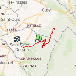

Length
12.2 km

Max alt
1119 m

Uphill gradient
457 m
Km-Effort
18.8 km

Min alt
587 m

Downhill gradient
598 m
Boucle
No
Creation date :
2019-05-09 07:07:45.741
Updated on :
2019-05-09 12:36:41.287
4h05
Difficulty : Very easy

FREE GPS app for hiking
 SityTrail
IGN / Geographical institutes
SityTrail Plus
The world is yours!
About
Trail Walking of 12.2 km to be discovered at Auvergne-Rhône-Alpes, Savoy, Saint-Offenge. This trail is proposed by Liebeaux.
Positioning
Country:
France
Region :
Auvergne-Rhône-Alpes
Department/Province :
Savoy
Municipality :
Saint-Offenge
Location:
Saint-Offenge-Dessous
Start:(Dec)
Start:(UTM)
267908 ; 5069150 (32T) N.
Comments