Trail Walking Municipality of Agia Galini - crete agia galini - Photo
© OpenStreetMap contributors
Length
Length
28 km
Max alt
Max alt
658 m
Uphill gradient
Uphill gradient
1056 m
Km-Effort
Km-Effort  
40 km
Min alt
Min alt
12 m
Downhill gradient
Downhill gradient
414 m
Boucle
Boucle
No
Creation date :
2019-05-10 05:07:41.021
Updated on :
2019-05-10 15:25:04.919

(0 Reviews)

Walking
Walking
8h43
Difficulty : Medium

Scan this QR Code to open this trail in the SityTrail application

FREE GPS app for hiking

Logo SityTrail SityTrail

IGN / Geographical institutes

Download SityTrail from the App Store Download SityTrail from Google Play

Logo SityTrail SityTrail World

The world is yours!

Download SityTrail from the App Store Download SityTrail from Google Play Download SityTrail on Huawei AppGallery

About

Trail Walking of 28 km to be discovered at Region of Crete, Rethymno Regional Unit, Municipality of Agia Galini. This trail is proposed by auffeuvre.

Description

beaucoup de route goudronnee

Elevation profile

Positioning

Country:
Greece
Region :
Region of Crete
Department/Province :
Rethymno Regional Unit
Municipality :
Municipality of Agia Galini
Location:
Unknown
Start:(UTM)
289188 ; 3886213 (35S) N.

Trails nearby

Trail Walking Municipality of Agia Galini - Crête-Agia Galini - Photo
Walking
equinox77

Walking

Medium
Municipality of Agia Galini, Region of Crete, Rethymno Regional Unit, Greece
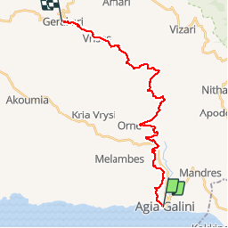
8 km | 12.1 km-effort
2h 32min
No
Trail Walking Municipality of Agia Galini - Crète-Agia Galini 08-04-2018 - Photo
Walking
fredetpascale

Walking

Easy
Municipality of Agia Galini, Region of Crete, Rethymno Regional Unit, Greece
6.1 km | 7.7 km-effort
1h 46min
Yes


Close
My subscriptions