


VTT rando du bugey

StephaneBM
User
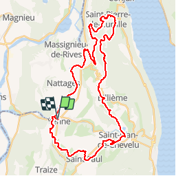

Length
42 km

Max alt
526 m

Uphill gradient
919 m
Km-Effort
55 km

Min alt
223 m

Downhill gradient
918 m
Boucle
Yes
Creation date :
2019-05-01 06:45:22.759
Updated on :
2019-05-15 11:22:31.622
4h12
Difficulty : Easy

FREE GPS app for hiking
 SityTrail
IGN / Geographical institutes
SityTrail Plus
The world is yours!
About
Trail Mountain bike of 42 km to be discovered at Auvergne-Rhône-Alpes, Savoy, Yenne. This trail is proposed by StephaneBM.
Positioning
Country:
France
Region :
Auvergne-Rhône-Alpes
Department/Province :
Savoy
Municipality :
Yenne
Location:
Unknown
Start:(Dec)
Start:(UTM)
714727 ; 5065041 (31T) N.
Comments