Trail Walking Municipal Unit of Loutraki - Perachora - 20190515 - Photo
 Frings
Frings

User

© OpenStreetMap contributors
Length
Length
221 km
Max alt
Max alt
1150 m
Uphill gradient
Uphill gradient
5001 m
Km-Effort
Km-Effort  
287 km
Min alt
Min alt
-1 m
Downhill gradient
Downhill gradient
5003 m
Boucle
Boucle
No
Creation date :
2019-05-15 07:15:49.781
Updated on :
2019-05-15 15:51:20.971

(0 Reviews)

Walking
Walking
1h00
Difficulty : Very easy
Car
Car
8h32
Difficulty : Very easy

Scan this QR Code to open this trail in the SityTrail application

FREE GPS app for hiking

Logo SityTrail SityTrail

IGN / Geographical institutes

Download SityTrail from the App Store Download SityTrail from Google Play

Logo SityTrail SityTrail World

The world is yours!

Download SityTrail from the App Store Download SityTrail from Google Play Download SityTrail on Huawei AppGallery

About

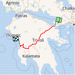
Trail Walking of 221 km to be discovered at Peloponnese, Western Greece and the Ionian, Corinthia Regional Unit, Municipal Unit of Loutraki - Perachora. This trail is proposed by Frings.

Elevation profile

Positioning

Country:
Greece
Region :
Peloponnese, Western Greece and the Ionian
Department/Province :
Corinthia Regional Unit
Municipality :
Municipal Unit of Loutraki - Perachora
Location:
Unknown
Start:(UTM)
676360 ; 4198655 (34S) N.

Trails nearby

Trail Motor Municipal Unit of Corinth - a-griekenland-ishtmia-griekenland - Photo
Motor
gpstracks

Motor

Very easy
Municipal Unit of Corinth, Peloponnese, Western Greece and the Ionian, Corinthia Regional Unit, Greece
163 km | 251 km-effort
Unknown
Yes


Close
My subscriptions