


rando dax sud à partir des chênes

jjduvar
User
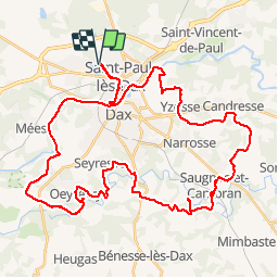

Length
54 km

Max alt
57 m

Uphill gradient
565 m
Km-Effort
61 km

Min alt
0 m

Downhill gradient
565 m
Boucle
Yes
Creation date :
2019-05-16 11:02:34.755
Updated on :
2019-05-16 14:48:16.004
3h44
Difficulty : Medium

FREE GPS app for hiking
 SityTrail
IGN / Geographical institutes
SityTrail Plus
The world is yours!
About
Trail Mountain bike of 54 km to be discovered at New Aquitaine, Landes, Saint-Paul-lès-Dax. This trail is proposed by jjduvar.
Photos


Positioning
Country:
France
Region :
New Aquitaine
Department/Province :
Landes
Municipality :
Saint-Paul-lès-Dax
Location:
Unknown
Start:(Dec)
Start:(UTM)
655858 ; 4843784 (30T) N.
Comments