Trail Electric bike Bouyon - boucle de Pous - Photo
 franquen
franquen

User

© OpenStreetMap contributors
Length
Length
50 km
Max alt
Max alt
910 m
Uphill gradient
Uphill gradient
1396 m
Km-Effort
Km-Effort  
68 km
Min alt
Min alt
315 m
Downhill gradient
Downhill gradient
1393 m
Boucle
Boucle
Yes
Creation date :
2019-05-16 08:57:38.479
Updated on :
2019-05-20 11:38:24.01

(0 Reviews)

Electric bike
Electric bike
4h26
Difficulty : Easy

Scan this QR Code to open this trail in the SityTrail application

FREE GPS app for hiking

Logo SityTrail SityTrail

IGN / Geographical institutes

Download SityTrail from the App Store Download SityTrail from Google Play

Logo SityTrail SityTrail World

The world is yours!

Download SityTrail from the App Store Download SityTrail from Google Play Download SityTrail on Huawei AppGallery

About

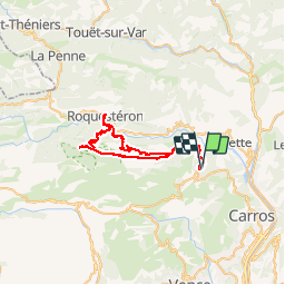
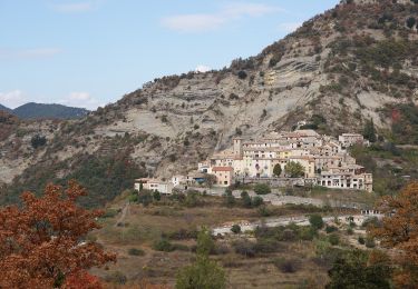
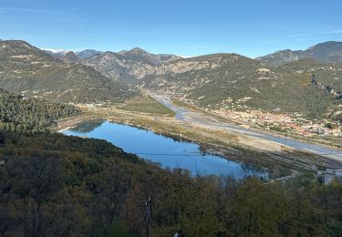
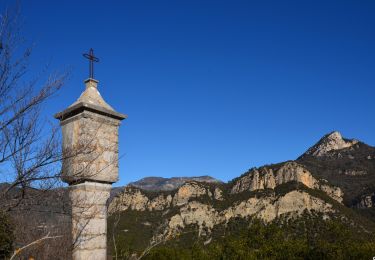
Trail Electric bike of 50 km to be discovered at Provence-Alpes-Côte d'Azur, Maritime Alps, Bouyon. This trail is proposed by franquen.

Description

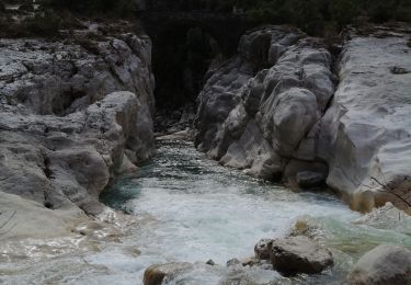
Départ de Bouyon jusqu'aux Ferres puis chemin du Vegay jusque Pous. descente sur Roquesteron et retour par Consegudes. Très beau chemin en encorbellement avec vue plongeante sur l'Esteron.

Elevation profile

Positioning

Country:
France
Region :
Provence-Alpes-Côte d'Azur
Department/Province :
Maritime Alps
Municipality :
Bouyon
Location:
Unknown
Start:(UTM)
349283 ; 4854414 (32T) N.

Trails nearby

Trail On foot Bouyon - track - Photo
On foot
domi06

On foot

Medium
(1)
Bouyon, Provence-Alpes-Côte d'Azur, Maritime Alps, France
16 km | 29 km-effort
6h 0min
Yes
Trail Walking Le Broc - Mouton d'Annou depuis lac du broc réel - Photo
Walking
GUIDE
jouans

Walking

Very difficult
Le Broc, Provence-Alpes-Côte d'Azur, Maritime Alps, France
17 km | 30 km-effort
6h 52min
Yes
Trail On foot Gilette - Tour du mont Lion - Photo
On foot
GUIDE+

On foot

Medium
Gilette, Provence-Alpes-Côte d'Azur, Maritime Alps, France
13.4 km | 25 km-effort
5h 44min
Yes
Trail On foot Bouyon - Gorges de l'Estéron - Photo
On foot
GUIDE+

On foot

Medium
Bouyon, Provence-Alpes-Côte d'Azur, Maritime Alps, France
12 km | 22 km-effort
5h 3min
Yes
Trail Walking Le Broc - mouton d'anou depuis le broc - Photo
Walking
Michel06

Walking

Easy
(1)
Le Broc, Provence-Alpes-Côte d'Azur, Maritime Alps, France
14.3 km | 23 km-effort
5h 13min
Yes
Trail Walking Le Broc - Le Broc-Bouyon fait - Photo
Walking
ETMU5496

Walking

Difficult
Le Broc, Provence-Alpes-Côte d'Azur, Maritime Alps, France
19.1 km | 31 km-effort
7h 0min
Yes
Trail Walking Le Broc - Le Broc (lac) ; le mouton d'Anou - Photo
Walking
ETMU5496

Walking

Medium
Le Broc, Provence-Alpes-Côte d'Azur, Maritime Alps, France
17 km | 30 km-effort
6h 51min
Yes
Trail Walking Gilette - Gilette - Pont de la Cerise - Photo
Walking
LtZIP

Walking

Medium
Gilette, Provence-Alpes-Côte d'Azur, Maritime Alps, France
17.2 km | 30 km-effort
4h 29min
Yes
Trail Walking Le Broc - ESTERON - Photo
Walking
Daniel Benteux

Walking

Easy
Le Broc, Provence-Alpes-Côte d'Azur, Maritime Alps, France
9.5 km | 12.5 km-effort
2h 44min
No


Close
My subscriptions