


Port Maubert

JeanPierreNancy
User
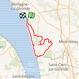

Length
45 km

Max alt
79 m

Uphill gradient
354 m
Km-Effort
50 km

Min alt
-2 m

Downhill gradient
353 m
Boucle
Yes
Creation date :
2019-05-16 12:25:04.511
Updated on :
2019-05-16 15:46:39.063
3h15
Difficulty : Very easy

FREE GPS app for hiking
 SityTrail
IGN / Geographical institutes
SityTrail Plus
The world is yours!
About
Trail Mountain bike of 45 km to be discovered at New Aquitaine, Charente-Maritime, Saint-Fort-sur-Gironde. This trail is proposed by JeanPierreNancy.
Positioning
Country:
France
Region :
New Aquitaine
Department/Province :
Charente-Maritime
Municipality :
Saint-Fort-sur-Gironde
Location:
Unknown
Start:(Dec)
Start:(UTM)
675708 ; 5033497 (30T) N.
Comments