Trail Walking Vilcey-sur-Trey - Vilcey-sur-Trey - Photo
© OpenStreetMap contributors
Length
Length
15.2 km
Max alt
Max alt
359 m
Uphill gradient
Uphill gradient
264 m
Km-Effort
Km-Effort  
18.7 km
Min alt
Min alt
232 m
Downhill gradient
Downhill gradient
264 m
Boucle
Boucle
Yes
Creation date :
2019-05-17 05:17:00.369
Updated on :
2019-06-24 09:56:32.595

(0 Reviews)

Walking
Walking
4h06
Difficulty : Difficult

Scan this QR Code to open this trail in the SityTrail application

FREE GPS app for hiking

Logo SityTrail SityTrail

IGN / Geographical institutes

Download SityTrail from the App Store Download SityTrail from Google Play

Logo SityTrail SityTrail World

The world is yours!

Download SityTrail from the App Store Download SityTrail from Google Play Download SityTrail on Huawei AppGallery

About

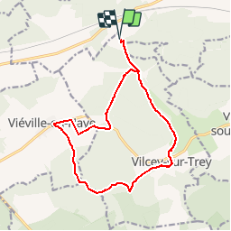
Trail Walking of 15.2 km to be discovered at Grand Est, Meurthe-et-Moselle, Vilcey-sur-Trey. This trail is proposed by grandville.

Description

randonnée de 15 km avec visite de la ferme et fromagerie de la Souleuvre

Elevation profile

Positioning

Country:
France
Region :
Grand Est
Department/Province :
Meurthe-et-Moselle
Municipality :
Vilcey-sur-Trey
Location:
Unknown
Start:(UTM)
716164 ; 5427735 (31U) N.

Trails nearby

Trail Walking Pagny-sur-Moselle - PAGNY SUR MOSELLE - VAL ET PLATEAU - Photo
Walking
jean-marie.parachini

Walking

Medium
Pagny-sur-Moselle, Grand Est, Meurthe-et-Moselle, France
18.1 km | 23 km-effort
6h 46min
Yes
Trail Walking Prény - Forêt de Preny dévastée quelle dommage - Photo
Walking
bitiba

Walking

Medium
Prény, Grand Est, Meurthe-et-Moselle, France
7.4 km | 9.7 km-effort
1h 14min
No
Trail Walking Prény - Marche Prény 2017 - Photo
Walking
pgydbt

Walking

Medium
(1)
Prény, Grand Est, Meurthe-et-Moselle, France
9.5 km | 13 km-effort
2h 41min
Yes
Trail Mountain bike Pagny-sur-Moselle - Vélo et Nature 2014 - Pagny sur Moselle - Photo
Mountain bike
tracegps

Mountain bike

Medium
Pagny-sur-Moselle, Grand Est, Meurthe-et-Moselle, France
34 km | 43 km-effort
2h 0min
Yes
Trail Walking Villecey-sur-Mad - Les aîtres médiévaux - Photo
Walking
fraxin

Walking

Easy
(1)
Villecey-sur-Mad, Grand Est, Meurthe-et-Moselle, France
17.2 km | 21 km-effort
4h 0min
Yes
Trail Mountain bike Vilcey-sur-Trey - Les villages du Saillant de St-Mihiel, aux portes de Pontà-Mousson. - Circuit n° 12 - Photo
Mountain bike
tracegps

Mountain bike

Difficult
Vilcey-sur-Trey, Grand Est, Meurthe-et-Moselle, France
47 km | 56 km-effort
2h 30min
Yes
Trail Cycle Jaulny - La vallée du Rupt de Mad - Circuit n° 14 - Jaulny - Photo
Cycle
tracegps

Cycle

Easy
Jaulny, Grand Est, Meurthe-et-Moselle, France
19.1 km | 22 km-effort
1h 0min
Yes
Trail Walking Pagny-sur-Moselle - Pagny sur Moselle - la Baume en haie - Preny - Photo
Walking
jean-marie.parachini

Walking

Medium
Pagny-sur-Moselle, Grand Est, Meurthe-et-Moselle, France
14 km | 17.4 km-effort
4h 50min
Yes
Trail Walking Norroy-lès-Pont-à-Mousson - Norroy - Montauville - Norroy - Photo
Walking
jean-marie.parachini

Walking

Easy
Norroy-lès-Pont-à-Mousson, Grand Est, Meurthe-et-Moselle, France
10.2 km | 12.5 km-effort
4h 8min
Yes


Close
My subscriptions