


Aix les Bains 23.05 2019

ffffff
User
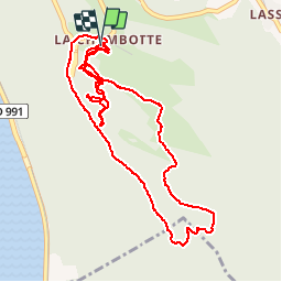

Length
6 km

Max alt
783 m

Uphill gradient
315 m
Km-Effort
10.2 km

Min alt
604 m

Downhill gradient
309 m
Boucle
Yes
Creation date :
2019-05-23 14:12:00.462
Updated on :
2019-05-23 20:14:51.297
1h31
Difficulty : Very easy

FREE GPS app for hiking
 SityTrail
IGN / Geographical institutes
SityTrail Plus
The world is yours!
About
Trail Walking of 6 km to be discovered at Auvergne-Rhône-Alpes, Savoy, Entrelacs. This trail is proposed by ffffff.
Positioning
Country:
France
Region :
Auvergne-Rhône-Alpes
Department/Province :
Savoy
Municipality :
Entrelacs
Location:
Saint-Germain-la-Chambotte
Start:(Dec)
Start:(UTM)
723486 ; 5073281 (31T) N.
Comments