


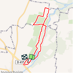
, les étangs Ingersheim

gilgeric
User

Length
7.6 km

Max alt
214 m

Uphill gradient
54 m
Km-Effort
8.3 km

Min alt
193 m

Downhill gradient
54 m
Boucle
Yes
Creation date :
2019-05-25 07:45:03.666
Updated on :
2019-05-25 13:55:27.073
1h34
Difficulty : Easy

FREE GPS app for hiking
 SityTrail
IGN / Geographical institutes
SityTrail Plus
The world is yours!
About
Trail Nordic walking of 7.6 km to be discovered at Grand Est, Haut-Rhin, Ingersheim. This trail is proposed by gilgeric.
Description
On longe les étangs la rivière puis on traverse un grand verger et retour sur les jardins
Positioning
Country:
France
Region :
Grand Est
Department/Province :
Haut-Rhin
Municipality :
Ingersheim
Location:
Unknown
Start:(Dec)
Start:(UTM)
374336 ; 5328850 (32U) N.
Comments