


19.5 km | 24 km-effort


User


FREE GPS app for hiking
 SityTrail
IGN / Geographical institutes
SityTrail World
The world is yours!
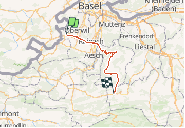
Trail Cycle of 27 km to be discovered at Basel-Landschaft, Bezirk Arlesheim, Biel-Benken. This trail is proposed by LCGsell.
Erste Strecke der Etappe 010CH07 von Basel nach Biel.
Von Biel-Benken, Hauptstrasse ins kleine Gewerbegebiet im Talgrund und nach Oberwil zur Tramstation. Der Gempen mit seinem Turm, unser Ziel, ist in Fahrtrichtung am Horizont zu sehen. Auf der Velospur entlang der Haupstrasse über den kleinen Hügel vom Birsig ins Birstal queren wir nach Rheinach und behalten die Richtung auf den Gempen bei, über Lichtsignal und durch Kreisel , über die Autobahn und die Birs bis zum Kreisel vor Dornach auf der anderen Talseite. Hier rechts am Coop vorbei und über die Eisenbahnlinie ins Dorf Dornach hinauf und den Wegweisern nach Gempen folgend auf der gleichmässig ansteigenden Strasse zum Gempen Plateau. Vor Gempen auf dem Plateau rechts herum nach Hochwald, das man nach wenigen Metern Anstieg mit einer Talfahrt erreicht. Durch Hochwald durch und über das offene Gelände und in grossen Kurven hinunter durch den Wald in die Ebene ( Achtung gefährliche Einfahrt in Talstrasse am Ende der Abfahrt) vor Seeven mit seiner zweitürmigen Dorfkirche. Durch Seeven nach rechts halten und leicht steigend am Weiher (altes Wasserreservoir für Basel) vorbei ins Seebachtälchen und leicht steigend entlang dem Bach nach Breztwil.
Schnell: 1h10. Langsam: 1h30
First Stretch of Stage 010CH07 from Basel to Biel. l.
From Biel-Benken cycle east to and through the small industrial park in the flatt valley towards Therwil having the Gempen Hill with its tower in front. Pass Therwils circles, tram tracks and traffic light keeping the direction east. Cross the small hill from the Birsig Valley to the Birs Valley on the bike line along the main road to reach Rheinach. Again without direction change cross all lights, tracks, lights and bridge over highway and Birs River to the circle on the other side of the valley. At this last circle turn right to Coop and across railway up to Dornach Village which you pass with a left-right turn following the signs to Gempen. The road climbs evenly at about 5with some switch backs through forest towards Gempen. Before Gempen on the Plateau turn right --> Seeven to the highest point and downhill to Hochwald which you pass to the open fields direction south-west. Enter the woods and downhill towards Seeven. Mind traffic from the right after the downhill and enter Seeven with its church of two towers. Pass Seeven keeping right and slightly climbing pass pond to your right which once was used as a drinking water reservoir for Basel. Cycle in the Seebach Valley following its brook to Bretzwil moderately climbing.
Fast : 1h10. Slow 1h30

Cycle

Walking
Walking
Walking
Mountain bike

Winter sports

Other activity
Other activity
Other activity