


Rocher de Jardanne par La Montagne Sigottier

claude nier
User
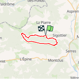

Length
16.1 km

Max alt
1622 m

Uphill gradient
772 m
Km-Effort
26 km

Min alt
933 m

Downhill gradient
770 m
Boucle
Yes
Creation date :
2019-05-28 12:32:49.229
Updated on :
2019-05-28 12:34:11.355
5h24
Difficulty : Very difficult

FREE GPS app for hiking
 SityTrail
IGN / Geographical institutes
SityTrail Plus
The world is yours!
About
Trail Walking of 16.1 km to be discovered at Provence-Alpes-Côte d'Azur, Hautes-Alpes, Sigottier. This trail is proposed by claude nier.
Description
a decouvrir
Positioning
Country:
France
Region :
Provence-Alpes-Côte d'Azur
Department/Province :
Hautes-Alpes
Municipality :
Sigottier
Location:
Unknown
Start:(Dec)
Start:(UTM)
711692 ; 4925818 (31T) N.
Comments