Trail Walking Beaufort - Tour ds le beaufortain - Photo

Tour ds le beaufortain

© OpenStreetMap contributors
Length
Length
37 km
Max alt
Max alt
2515 m
Uphill gradient
Uphill gradient
2107 m
Km-Effort
Km-Effort  
65 km
Min alt
Min alt
1569 m
Downhill gradient
Downhill gradient
2122 m
Boucle
Boucle
No
Creation date :
2014-12-10 00:00:00.0
Updated on :
2014-12-10 00:00:00.0

(0 Reviews)

Walking
Walking
10h00
Difficulty : Medium

Scan this QR Code to open this trail in the SityTrail application

FREE GPS app for hiking

Logo SityTrail SityTrail

IGN / Geographical institutes

Download SityTrail from the App Store Download SityTrail from Google Play

Logo SityTrail SityTrail World

The world is yours!

Download SityTrail from the App Store Download SityTrail from Google Play Download SityTrail on Huawei AppGallery

About

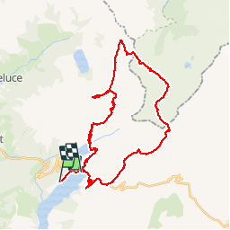
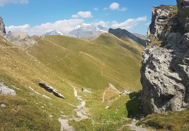
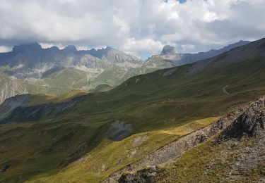
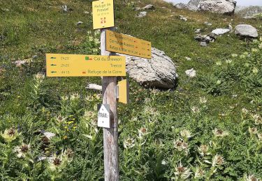
Trail Walking of 37 km to be discovered at Auvergne-Rhône-Alpes, Savoy, Beaufort. This trail is proposed by freddy73800.

Description

Tour à faire le 03/08

Elevation profile

Positioning

Country:
France
Region :
Auvergne-Rhône-Alpes
Department/Province :
Savoy
Municipality :
Beaufort
Location:
Unknown
Start:(UTM)
315747 ; 5062858 (32T) N.

Trails nearby

Trail Walking Beaufort - Du refuge du Plan de la laie au refuge de la Croix du Bonhomme - Photo
Walking
GUIDE
Desrumaux

Walking

Medium
(1)
Beaufort, Auvergne-Rhône-Alpes, Savoy, France
8 km | 16 km-effort
4h 27min
No
Trail Walking Beaufort - lac de Presset et passeur de la Mintaz (belvédère de la Pierra Menta) - Photo
Walking
GUIDE
amiral13

Walking

Difficult
Beaufort, Auvergne-Rhône-Alpes, Savoy, France
11.6 km | 24 km-effort
2h 57min
Yes
Trail Walking Beaufort - Ref de la Laie vers refuge du Presset - Photo
Walking
stjullie

Walking

Medium
(1)
Beaufort, Auvergne-Rhône-Alpes, Savoy, France
10.6 km | 19.8 km-effort
5h 17min
No
Trail Walking Beaufort - Brèche de Parozan - Photo
Walking
GuyVachet

Walking

Very difficult
Beaufort, Auvergne-Rhône-Alpes, Savoy, France
9.6 km | 23 km-effort
4h 29min
Yes
Trail Walking Beaufort - Col et lac du grand fond  - Photo
Walking
Le_Grand

Walking

Very difficult
Beaufort, Auvergne-Rhône-Alpes, Savoy, France
13.3 km | 23 km-effort
5h 15min
Yes
Trail Walking Beaufort - Col de la Sauce, Rocher du Vent - Photo
Walking
GUIDE
David25400

Walking

Easy
Beaufort, Auvergne-Rhône-Alpes, Savoy, France
9.1 km | 17.6 km-effort
3h 51min
Yes
Trail Walking Beaufort - Lac d'Amour - Photo
Walking
GUIDE
David25400

Walking

Easy
Beaufort, Auvergne-Rhône-Alpes, Savoy, France
21 km | 35 km-effort
6h 22min
Yes
Trail Walking Beaufort - BEAUFORTIN: DE TREICOL AU REFUGE DE PRESSET - Photo
Walking
djeepee74

Walking

Medium
Beaufort, Auvergne-Rhône-Alpes, Savoy, France
9.1 km | 19.1 km-effort
3h 10min
No
Trail Touring skiing Beaufort - Fontana - la Gittaz - Rocher des Enclaves - Col du Sallestet - Pas d'Outray - les Merands - Photo
Touring skiing
bill73

Touring skiing

Very easy
Beaufort, Auvergne-Rhône-Alpes, Savoy, France
21 km | 43 km-effort
5h 32min
No


Close
My subscriptions