


Mendionde

jcm17
User

Length
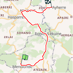
13.2 km

Max alt
198 m

Uphill gradient
192 m
Km-Effort
16.2 km

Min alt
36 m

Downhill gradient
325 m
Boucle
No
Creation date :
2019-06-02 08:24:42.194
Updated on :
2019-06-02 19:06:10.061
9h10
Difficulty : Very easy

FREE GPS app for hiking
 SityTrail
IGN / Geographical institutes
SityTrail Plus
The world is yours!
About
Trail Car of 13.2 km to be discovered at New Aquitaine, Pyrénées-Atlantiques, Mendionde. This trail is proposed by jcm17.
Positioning
Country:
France
Region :
New Aquitaine
Department/Province :
Pyrénées-Atlantiques
Municipality :
Mendionde
Location:
Unknown
Start:(Dec)
Start:(UTM)
637852 ; 4800319 (30T) N.
Comments