


MUNSTER - 17 KM

Corsica76
User
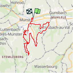

Length
16.9 km

Max alt
817 m

Uphill gradient
652 m
Km-Effort
26 km

Min alt
366 m

Downhill gradient
653 m
Boucle
Yes
Creation date :
2019-06-03 16:56:34.853
Updated on :
2019-06-03 17:00:37.718
5h19
Difficulty : Very difficult

FREE GPS app for hiking
 SityTrail
IGN / Geographical institutes
SityTrail Plus
The world is yours!
About
Trail Walking of 16.9 km to be discovered at Grand Est, Haut-Rhin, Munster. This trail is proposed by Corsica76.
Positioning
Country:
France
Region :
Grand Est
Department/Province :
Haut-Rhin
Municipality :
Munster
Location:
Unknown
Start:(Dec)
Start:(UTM)
361783 ; 5322684 (32U) N.
Comments