


étang vallier brossac

bert16
User
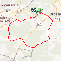

Length
8 km

Max alt
165 m

Uphill gradient
139 m
Km-Effort
9.9 km

Min alt
92 m

Downhill gradient
138 m
Boucle
Yes
Creation date :
2019-06-04 07:02:27.826
Updated on :
2019-06-04 09:07:35.94
2h04
Difficulty : Easy

FREE GPS app for hiking
 SityTrail
IGN / Geographical institutes
SityTrail Plus
The world is yours!
About
Trail Walking of 8 km to be discovered at New Aquitaine, Charente, Brossac. This trail is proposed by bert16.
Description
Association des anciens élèves et amis de Brie-sous-chalais 16210.
Photos


Positioning
Country:
France
Region :
New Aquitaine
Department/Province :
Charente
Municipality :
Brossac
Location:
Unknown
Start:(Dec)
Start:(UTM)
730505 ; 5023659 (30T) N.
Comments