Trail Hybrid bike Hondschoote - Circuit vélo Dunkerque-Bergues - Photo

Circuit vélo Dunkerque-Bergues

© OpenStreetMap contributors
Length
Length
58 km
Max alt
Max alt
18 m
Uphill gradient
Uphill gradient
244 m
Km-Effort
Km-Effort  
61 km
Min alt
Min alt
-5 m
Downhill gradient
Downhill gradient
244 m
Boucle
Boucle
Yes
Creation date :
2019-06-04 13:45:14.405
Updated on :
2019-06-04 15:17:58.174

(0 Reviews)

Hybrid bike
Hybrid bike
--
Difficulty : Very easy

Scan this QR Code to open this trail in the SityTrail application

FREE GPS app for hiking

Logo SityTrail SityTrail

IGN / Geographical institutes

Download SityTrail from the App Store Download SityTrail from Google Play

Logo SityTrail SityTrail World

The world is yours!

Download SityTrail from the App Store Download SityTrail from Google Play Download SityTrail on Huawei AppGallery

About

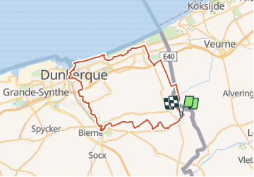
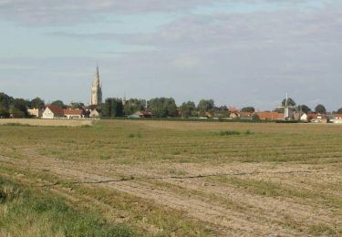
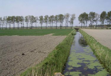
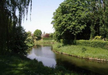
Trail Hybrid bike of 58 km to be discovered at Hauts-de-France, Nord, Hondschoote. This trail is proposed by project32.

Description

Partez découvrir le sud dunkerquois à vélo. Vous découvrirez la ville de Coudekerque Branche et Coudekerque village avec son bois des forts et le parc du fort Louis. Sur la route vous traverserez la ville fortifiée de Bergues et ses canaux.

Elevation profile

Positioning

Country:
France
Region :
Hauts-de-France
Department/Province :
Nord
Municipality :
Hondschoote
Location:
Unknown
Start:(UTM)
470972 ; 5647823 (31U) N.

Trails nearby

Trail On foot Veurne - Ringslot wandelroute - Photo
On foot
PRO

On foot

Easy
Veurne, Flanders, West Flanders, Belgium
9.1 km | 9.5 km-effort
2h 8min
Yes
Trail Cycle Hondschoote - La route du lin 2014 - Hondschoote - Photo
Cycle
tracegps

Cycle

Medium
Hondschoote, Hauts-de-France, Nord, France
28 km | 30 km-effort
2h 0min
Yes
Trail Cycle Hondschoote - La route du lin 2013 - Hondschoote - Photo
Cycle
tracegps

Cycle

Easy
Hondschoote, Hauts-de-France, Nord, France
35 km | 37 km-effort
2h 0min
Yes
Trail Mountain bike Hondschoote - La route du lin 2013 - Hondschoote - Photo
Mountain bike
tracegps

Mountain bike

Easy
Hondschoote, Hauts-de-France, Nord, France
35 km | 37 km-effort
3h 0min
Yes
Trail Cycle Hondschoote - La route du lin 2011 - Hondschoote  - Photo
Cycle
tracegps

Cycle

Easy
(1)
Hondschoote, Hauts-de-France, Nord, France
33 km | 34 km-effort
2h 0min
Yes
Trail Mountain bike Hondschoote - La route du lin 2011 - Hondschoote  - Photo
Mountain bike
tracegps

Mountain bike

Easy
Hondschoote, Hauts-de-France, Nord, France
33 km | 34 km-effort
3h 0min
Yes
Trail Walking Hondschoote - Circuit des chapelles (Hondschoote) - Photo
Walking
tracegps

Walking

Difficult
Hondschoote, Hauts-de-France, Nord, France
19 km | 20 km-effort
4h 45min
Yes
Trail Walking Ghyvelde - Les Moëres - Photo
Walking
tracegps

Walking

Difficult
Ghyvelde, Hauts-de-France, Nord, France
15.1 km | 15.6 km-effort
3h 45min
Yes
Trail Walking Hondschoote - Circuit des Anguilles - Hondschoote - Photo
Walking
tracegps

Walking

Medium
(2)
Hondschoote, Hauts-de-France, Nord, France
9.4 km | 9.8 km-effort
2h 15min
Yes


Close
My subscriptions