


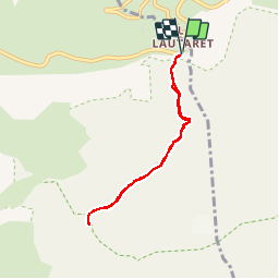
Col de Laurichard (6 km - D. 622 m)

Thomasdanielle
User

Length
5.9 km

Max alt
2656 m

Uphill gradient
622 m
Km-Effort
14.2 km

Min alt
2036 m

Downhill gradient
626 m
Boucle
Yes
Creation date :
2019-06-08 07:59:12.499
Updated on :
2019-06-08 08:21:44.888
--
Difficulty : Medium

FREE GPS app for hiking
 SityTrail
IGN / Geographical institutes
SityTrail Plus
The world is yours!
About
Trail On foot of 5.9 km to be discovered at Provence-Alpes-Côte d'Azur, Hautes-Alpes, Villar-d'Arêne. This trail is proposed by Thomasdanielle.
Description
D/A : Parking du Lautaret ??
Suivre le sentier des crevasses sur la gauche puis laisser ce sentier et se diriger vers le col de Laurichard.
Positioning
Country:
France
Region :
Provence-Alpes-Côte d'Azur
Department/Province :
Hautes-Alpes
Municipality :
Villar-d'Arêne
Location:
Unknown
Start:(Dec)
Start:(UTM)
295593 ; 4989914 (32T) N.
Comments