


randogps66-414

pythonmichel
User
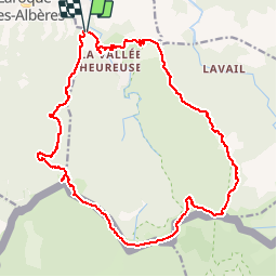

Length
23 km

Max alt
1246 m

Uphill gradient
1460 m
Km-Effort
42 km

Min alt
143 m

Downhill gradient
1460 m
Boucle
Yes
Creation date :
2019-06-12 09:07:11.457
Updated on :
2019-06-12 10:00:00.005
8h29
Difficulty : Difficult

FREE GPS app for hiking
 SityTrail
IGN / Geographical institutes
SityTrail Plus
The world is yours!
About
Trail Walking of 23 km to be discovered at Occitania, Pyrénées-Orientales, Sorède. This trail is proposed by pythonmichel.
Positioning
Country:
France
Region :
Occitania
Department/Province :
Pyrénées-Orientales
Municipality :
Sorède
Location:
Unknown
Start:(Dec)
Start:(UTM)
496223 ; 4707172 (31T) N.
Comments